
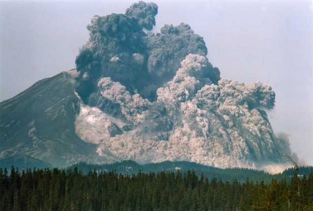
Facts and Science against Evolution: Mount St. Helens is located in Washington State and is said by the U. S. Geological Survey (USGS) “to be the most active volcano in the Cascade Range, and it is the most likely of the contiguous U. S. volcanoes to erupt in the future.” On May 18, 1980, the mountain made history as the most catastrophic eruption in America in the last few hundred years.
| According to Mountsthelens.com Information Resource Center, the mountain use to be called by certain Indians, ‘Louwala-Clough,’ or ‘Smoking Mountain.’ In 1792, Captain Vancouver (also named Mount Rainier) named it in honor of Baron A. Fitzherbert St. Helens, then British Ambassador to Spain. “A magnitude 4.2 earthquake on March 20, 1980… preceded by several much smaller earthquakes beginning as early as March 16, was the first substantial indication of Mount St. Helen’s awakening from its 123-year sleep… the next 2 days… 174 shocks with magnitudes greater than 2.6 were recorded… Aerial observations… revealed small earthquake-induced avalanches… but no sign of an eruption…’
‘With a thunderous explosion… March 27, Mount St. Helens began to spew ash and steam, marking the first significant eruption in the conterminous United States since …1917. The crown of the ash column rose to about 6,000 feet above the volcano. The initial explosions formed a 250-foot-wide crater… Through April 21, Mount St. Helens intermittently ejected ash and steam… The ash blown out between March 27 and May 18 was derived entirely from the 350-year-old summit dome… high-temperature steam and gases; no magma…’ ‘May 18, a Sunday… volcanologist David A. Johnston, who had Saturday-night duty at an observation post about 6 miles north of the volcano, radioed in the results of some laser-beam measurements… about an hour and a half later… 8:32 a.m. PDT, apparently in response to a magnitude 5.1 earthquake about 1 mile beneath the volcano, the bulged, unstable north flank of Mount St. Helens suddenly began to collapse, triggering a rapid and tragic train of events that resulted in widespread devastation and the loss of 57 people, including volcanologist Johnston.” |
| Thus the explosion was initiated by an earthquake and rockslide where a mass of the North Slope slid off and pressure was released. According to the USGS, “magma began intruding into the Mount St. Helens edifice in the late winter and early spring of 1980. By May 18, the cryptodome (bulge) on the north flank had likely reached the point of instability, and was creeping more rapidly toward failure. A magnitude 5+ earthquake was accompanied by a debris avalanche, which in turn unloaded the confining pressure at the top of the volcano by removing the cryptodome. This abrupt pressure release allowed hot water in the system to flash to stream, which expanded explosively, initiating a hydrothermal blast directed laterally through the landslide scar… the pressure decreased… down the volcanic conduit to the subsurface magma reservoir, which then began to rise, form bubbles and erupt explosively, driving a 9-hour long Plinian (enormous columns of tephra and gas) eruption… Scientists estimate that the eruption reached its peak between 3:00 and 5:00 p.m.’
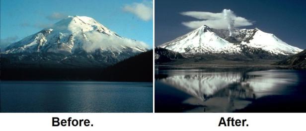
‘When the Plinian phase was over, a new northward opening summit amphitheater 1.2 x 1.8 miles across was revealed. Over the course of the day, prevailing winds blew 520 million tons of ash eastward across the United States and caused complete darkness in Spokane, Washington, 250 miles from the volcano… ash fell visibly as far eastward as the Great Plains of the Central United States, more than 930 miles away. The ash cloud spread across the U.S. in three days and circled the Earth in 15 days…’ ‘…The turbulently flowing hot rocks and gas quickly eroded and melted some of the snow and ice capping the volcano, creating surges of water that eroded and mixed with loose rock debris to form lahars (volcanic mudflow or debris flow). Several lahars poured down the volcano into river valleys, ripping trees from their roots and destroying roads and bridges…” |
On May 18, when Mount St. Helens erupted with a catastrophic Lateral blast explosion estimated to be the equivalent to about 24 megatons (million tons) of TNT (note: Hiroshima’s unranium bomb was equal to about 15 kilotons of TNT; Nagasaki’s plutonium was about 21 kt TNT; Tsar Bomba – was powerful nuclear bomb detonated equaled 50,000 kt TNT or 50 megatons – 50 million tons of TNT), the top 1,300 feet of the mountain blew off sending tens of thousands of trees into the nearby Spirit Lake. A sonar scan of the bottom of the lake revealed about 19,500 upright trees on the bottom of the lake. Millions of logs were left floating over a 2’ mile area. Due to massive amounts of debris (rock/trees) the lake rose as much as 190 feet.

Millions of logs in Spirit Lake; ship in circle
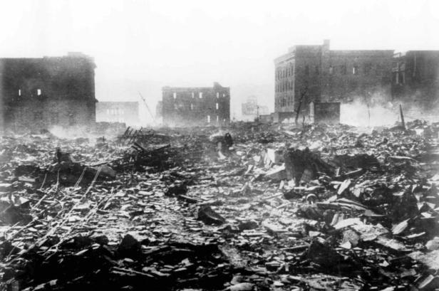
above: Nagasaki; below: Mt. St. Helen’s

Tsar Bomb (below)

A Case for Creationism and against Evolution
Point 1: According to most geologists, petrification (rare fossilization process of turning organic material – most often wood – into stone) must take place over hundreds of thousands or millions of years.
Geology.com (2/2017) states, “petrified wood is a fossil. It forms when plant material is buried by sediment and protected from decay due to oxygen and organisms… Petrified Forest National Park… Arizona; about 225 million years ago, this area was a lowland …rivers flooded by tropical rain storms washed mud and other sediments into the lowlands. Enormous coniferous trees up to …200 feet tall lived and died in these lowlands. Fallen trees… were often buried by the river sediments. Nearby volcanoes erupted numerous times… rapid burial allowed the plant debris to escape destruction by oxygen and insects. The soluble ash was dissolved by groundwater… and served as a source of silica that replaced the plant debris, creating petrified wood… in the millions of years after the Chinle Formation was deposited, the area was uplifted…”
According to Livescience.com (2/2017), “Petrified wood forms when fallen trees get washed down a river and buried under layers of mud, ash from volcanoes and other materials… over millions of years, these minerals crystallize within the wood’s cellular structure forming the stone-like material known as petrified wood.”
According to petrifiedwoodmuseum.org, “How long it takes to form petrified wood… fossil wood that has little to no wood remaining has cellular detail replicated in opal-CT… conversion of silica to …opal A, to opal-CT… to quartz… requires millions of years.” “Under normal conditions conversion of opal to quartz requires tens of millions of years; however, under geothermal conditions the same process may occur in 50,000 years of less (Mustoe 2003)… a Yellowstone Wyoming sample carbon dated at 2,430 years was composed of opal-A.”
TRUTH: During the Mt. St. Helens eruptions, the explosion destroyed and relocated about 150 square miles of forest in a little more than five (5) minutes; swirling gases reached 900°C (over 1,600°F), and a few years later sonar scans of the bottom of Spirit Lake revealed about 19,500 upright trees. Also, a grand canyon was instantly created at the mountain.
At Spirit Lake a study found that logs that had root stumps rapidly up righted themselves and took a vertical position. Of the thousands of trees due to weight, times of deposit (months to years), and location of the lake bottom; the trees settled at different depth levels into the soil or CHANGING how many scientists now view ‘petrified forests’ in the Stratigraphic Records.
May 2010, a National Geographic article, on Mount St. Helens called ‘Mountain Transformed’ stated, “At the bottom of Spirit Lake… 20-year-old Olympia flattops …preserved by the clear, cold water… a sunken rowboat from the YMCA camp… a ‘petrified’ forest: a ghostly stand of sunken, branchless firs, buried upright dozens of yards below the surface… evidence of a past eruption…”
Some of the 20 year old trees that were thrown into Spirit Lake in 1980 and that had petrified by an August 1982 investigation were carbon dated between 100 years old and 36,000 years old in a study by Karowe and Jefferson. They noted there are similar trees in Yellowstone and Antarctica.
Dr. Steven Austin (ICR; Geologist) explains, “many of the logs showed a strong tendency to float upright. Over the first 10 years after the eruption, about half of the original logs which floated in the lake sank to the floor of the lake. When Dr Austin and other scientists used sonar and scuba to examine the bottom of the lake, they found that about 10 per cent of the deposited logs were in upright position—looking like an underwater forest!”
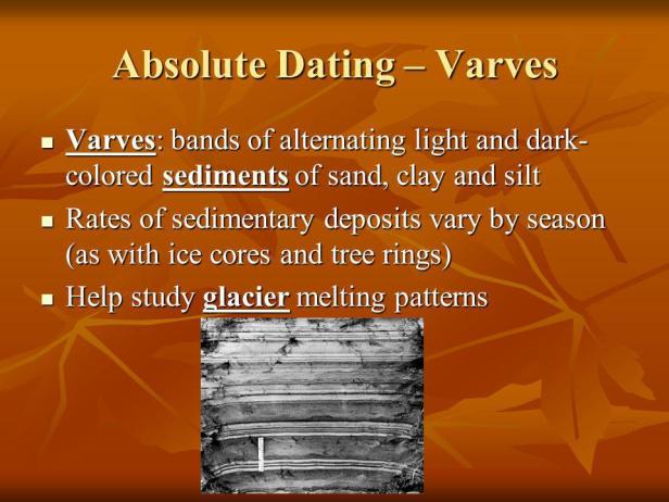
Point 2: Sediment and Varve Dating
According to most scientists, sediment deposits on lake bottoms can reveal age. Scientists when Dating Sedimentary Strata can use ‘Relative Dating (assuming one fossil age vs. another with ‘radioactive analysis’),’ and ‘Absolute Dating (looking at samples of varved shale, or layers in the lake bottom sediments (‘varves’) that is assumed to occur between seasons.
If Spirit Lake could be drained, it would look like forests of trees which had grown at different levels and at different times—perhaps over thousands of years. At a place called Specimen Ridge at Yellowstone, there are petrified upright trees, at many different levels. These have been interpreted as representing many different forests, growing successively on the same place over long periods of time. This is supposedly one of the best evidences evolutionists use to ‘prove’ long time periods for the earth’s history. However, it is now possible to explain this same evidence in terms of a similar event to that at Mount St Helens—a catastrophic event that enables scientists to reinterpret the evidence at Yellowstone as having formed within a short time.
| ICR.org RAPIDLY FORMED STRATIFICATION
“Up to 400 feet thickness of strata has formed since 1980 at Mount St. Helens. These deposits accumulated from primary air blast, landslide, waves on the lake, pyroclastic flows, mudflows, air fall, and stream water. Perhaps the most surprising accumulations are the pyroclastic flow deposits amassed from ground-hugging, fluidized, turbulent slurries of fine volcanic debris, which moved at high velocities off the flank of the volcano as the eruption plume of debris over the volcano collapsed. These deposits include fine pumice ash laminae and beds from one millimeter thick to greater than one meter thick, each representing just a few seconds to several minutes of accumulation. A deposit accumulated in less than one day, on June 12, 1980, is 25 feet thick and contains many thin laminae and beds. Conventionally, sedimentary laminae and beds are assumed to represent longer seasonal variations, or annual changes, as the layers accumulated very slowly. Mount St. Helens teaches us that the stratified layers commonly characterizing geological formations can form very rapidly by flow processes. Such features have been formed quickly underwater in laboratory sedimentation tanks, and it should not surprise us to see that they have formed in a natural catastrophe.” |
Often, varves of 1 to 5 cm are considered a year. Again, varves are horizontal bedding structures such as at lake bottoms or deep marine environments. A rhythmite is bedding that is in a repetitious sequence, often very thin and containing alternating types of sediment particles. A varve is a type of rhythmite where alternating layers are thicker or coarser followed by a thinner and fine-grained layer. This is due to changes in seasonal rains and temperature.
By 40 years after the Volcano sediment was up to 600’ deep in the lake bottom.

Point 3: Natural Disaster and Erosion produced varves
The volcano and rockslide produced waves up to 850 feet high in Spirit Lake. Also, on one of the post-volcanic new shores, a cliff up to 20’ high was cut by erosion very rapidly. Also a small ‘Grand Canyon’ over 100’ deep was created in the North Fork and new canyons at the North Toutle River. The 100’ canyon was due to rushing water, mud, and erosion and pumice deposits. It was created to that depth by August 1984, a little more than 4 years.
Another example by a different natural disaster was in 1974 in Brazil; when June 8, a rain storm eroded and turned a small gully in a valley into a 16’ deep, 50’ wide and 1,600’ long little canyon.
Many Scientists in the past have dated canyons and glaciers by using varve records of the ‘annual’ layers. Thicknesses of annual layers are counted and measured to formulate a time scale of varve years. Additionally, C-14 dating is used to confirm. Two BIG problems here; first C-14 dating can only be used properly up to about 5000 years. Even then live shellfish have been C-14 dated to be hundreds or even 1,000 years old. Second, the annual measurements are most often assumed because they were not there each original year to measure. And thus, they assume based on drying processes and various fossils found in the layer to tell them each year and so on. However, in a natural disaster the living organisms and previous positioned fossils can get thrown into a ‘washing machine’ or ‘tornado’ type affect and all be mixed together, thus, years later giving an appearance of hundreds or thousands of years old in a 10’ deep core sample; when in fact to 10’ area could have been created by disaster in less than a week.

Green River Canyon; Mt. St. Helens
In truth created in less than 4 years; but by typical ‘varve’ dating could be recorded at a million years old.
